![]()
Coasts
Rivers/Lakes
Lowlands/Plains
Geysers/Mud
Glaciers
Mt. Ruapehu
Mt. Cook
White Island
A Maori Legend
![]()
Abbotsford
Aramoana
Ballantynes
Brynderwyns
Cave Creek
Hawkes Bay
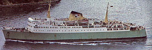
H.M.S. Orpheus
Influenza
Mt. Erebus
Mt. Tarawera
Rainbow Warrior
Seacliff Hospital
Tangiwai
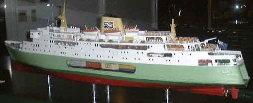
Wahine
![]()
Annie Aves
Ata-hoe
Daisy Basham
Jean Batten
Minnie Dean
Mabel Howard
Margaret Mahy
Kath Mansfield
Kate Sheppard
Kiri Te Kanawa
Catherine Tizard
Murray Ball
Charles Goldie
Edmund Hillary
Richard Pearse
Lord Rutherford
Charles Upham
![]()
NZ FAQ--Funny
NZ Links
Credits
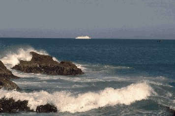
New Zealand is only a small country but it has an extensive coastline covering more than 1600 km -- larger than that of the United States. Neither the North or South Island exceeds 450 km at its broadest point so New Zealand possesses a very lengthy coastline in proportion to its area. Three islands make up the country, the North Island, the South Island and a third much smaller island, Stewart Island. Cook Strait divides the North and South Islands, while a much smaller body of water, Foveaux Strait, separates the South Island from Stewart Island. The total land area is 268,000 kilometres, a little larger than Britain and Japan, and slightly smaller than Italy. New Zealand lies in the south-western corner of the Pacific Ocean and is so close to the international dateline that Mount Hikurangi on the east coast of the North Island is said to be the first place in the world to see the dawn of each new day. National boundaries include islands like the Chathams, the Kermadecs and Campbell Island. The country also has jurisdiction over the Ross Dependency in Antarctica and administers the Tokelau group of islands. The name New Zealand was first used by Dutch geographers in the 17th century. Maori call the country Aotearoa which is commonly translated as 'the Land of the Long White Cloud'.
Ferries traverse Cook Strait between Picton and Wellington though sailings can be disrupted by the weather occurring in that area. Cook Strait lies in the 'Roaring Forties' which makes it prone to strong gales and powerful currents. It is considered one of the more dangerous stretches of water in the world. During one part of the early 70's three ferries plied these waters, now there are two passenger and vehicle ships, Arahura and Aratika, plus the Lynx, a 74 metre catamaran which operates during the summer season only. Travelling times differ for each vessel: 3 hours on the Arahura, 3 hours 20 minutes on the Aratika and 1 hour 45 minutes for the Lynx. Several slightly demented people, (in my personal view!), have swum the Strait which is about 20 kilometres across at its narrowest point. The first recorded crossing, (Maori legends not withstanding), was made by Barrie Davenport in 1962, this took 11 hours, 13 minutes, but the time has since been beaten on many occasions. The first woman to swim the Strait was American Lynne Cox. In 1978, 16 year-old-schoolgirl, Meda McKenzie became the first person to swim across in both directions while the first return crossing was made by Philip Rush in 1984. His time was 16 hours, 16 minutes. At this time the record for the fastest crossing is held by Denise Anderson, who aged 14, swum the Strait in only 5 hours, 4 minutes. Due to the 'Queens Chain' law, all coastlines and river banks (within 20m) are available for public use -- the coastline is legally public land. However, frequently access to some of these areas is restricted or impossible because of the need to cross private land to get to them. There is no coral reef anywhere about the country, this being the only 'geographical feature' New Zealand lacks.
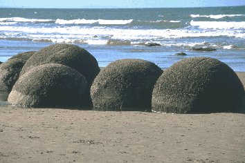
One of the more unusual features on the New Zealand coastline occurs at Hampden, 80 kilometres north of Dunedin. The Moeraki boulders are perfectly spherical and were formed 60 million years ago by the gradual accumulation of lime salts round small centres on the sea floor. Fossil shells, bone fragments or pieces of wood lie at the centre of these rocks. Although treasure hunters have removed many examples those that remain weigh some several tonnes and have a circumference of around three metres. Fair enough to say that no one will be removing the remaining boulders, not only due to the massive weight, but also because this area has now been protected as a scientific reserve. When it comes to spectacular beaches one of the most well-known is Ninety Mile Beach. This is at the extreme North of New Zealand and the name is incorrect since the beach is nearer to sixty miles long (96 kilometres). It is thought the original length of the beach may have been calculated in kilometres and confusion occured during the naming. It's a great tourist destination with buses travelling the beach at 100 kilometres (over 60 miles) per hour. There are traps for drivers on the beach including quicksand and pounding waves. The risks are real and buses carry shovels just in case the driver misjudges! Ninety Mile Beach is a good hunting ground for a New Zealand favourite shellfish. The Toheroa is a clam which has a distinctive flavour. It is extremely popular in soup, however you're not very likely to taste it as this shellfish is now extremely rare and annual seasons for Toheroa collection have now been suspended for a large number of years.
|