![]()
Coasts
Rivers/Lakes
Lowlands/Plains
Geysers/Mud
Glaciers
Mt. Ruapehu
Mt. Cook
White Island
A Maori Legend
![]()
Abbotsford
Aramoana
Ballantynes
Brynderwyns
Cave Creek
Hawkes Bay
H.M.S. Orpheus
Influenza
Mt. Erebus
Mt. Tarawera
Rainbow Warrior
Seacliff Hospital
Tangiwai
Wahine
![]()
Annie Aves
Ata-hoe
Daisy Basham
Jean Batten
Minnie Dean
Mabel Howard
Margaret Mahy
Kath Mansfield
Kate Sheppard
Kiri Te Kanawa
Catherine Tizard
Murray Ball
Charles Goldie
Edmund Hillary
Richard Pearse
Lord Rutherford
Charles Upham
![]()
NZ FAQ--Funny
NZ Links
Credits

August 8th, 1979. In New Zealand when one thinks of natural disasters things like earthquakes, floods, storms or volcanic eruptions come to mind. Few people think, 'landslide'. Yet slips of this kind frequently occur in New Zealand washing out roads or causing one or two houses to become unlivable. When the unstable land at Abbotsford decided to move, the effects on roads, houses and people were just as significant as in any other major natural disaster.
In any situation this combination is very unstable, but add to the problems that of being on sloping land and it was just a matter of time before the entire area slipped as if it was composed of millions of ball bearings. On this type of land this is indeed the effect, especially when the soil becomes excessively wet. There are records of numerous slips at Abbotsford. The first signs came during the building of the Dunedin to Mosgiel railway in 1914. At this time there was a huge slip near the Neill Street bridge. Just after World War II, during the laying of the Dunedin city water mains the pipes had to be routed away from the Abbotsford area as the land was so unstable. Despite all this, plans were drawn up for a housing development in the area. During 1951, a report was written based on a geological survey of the area. The report was looking at possible sites for new housing. In this report the author stated that, "The area of lose sand at Abbotsford ia, as its name suggests, a particularly treacherous formation which interferes with building foundations in areas where it occurs. It should be noted that on similar formations at Seacliff Hospital, buildings erected on this type of land moved several feet in four years and had eventually had to be demolished. If stabilisation measures are not undertaken, the steady erosion caused by the slips and quarrying around Miller's Park will leave the area derelict within a quarter of a century." On a map was marked the area of land affected by this report and unsuitable for housing development. All of the land within this triangle was affected by the 1979 Abbotsford landslip. It's unknown how, but the contents of this report and the carefully marked danger area were were either lost or ignored and disappeared from maps later used for urban planning and development. During subdivision several watercourses were built to handle run off or rainwater but it was observed that during heavy downfalls these had difficulty coping with the extra water and large ponds of water would bank up. 1966 came and three houses were demolished as a result of some slipping which occurred during motorway construction. Then, in January 1968, a very large slip happened, again as a result of motorway construction. This was replaced with a very large quantity of fill. No. 5 Christie Street. Between 1968 and 1971 the owner of another house noticed cracks appearing in his foundations. As this was not covered by insurance he paid himself to have the foundations underpinned and a drain laid across his lawn. Seven years later, after further subsidence, he had his tile roof replaced with a corrugated iron one in an effort to lighten the house. Cracks developed in other houses, block work started to separate. Increasing signs of movement began to show up. In May 1979 the Council had to fix the drains which had separated by more than half a metre. Then, in June, a fissure developed in one street which was followed closely by both the water main and sewerage pipes fracturing. Days later, more breaks in the water mains. Back at Christie Street the residents were advised to leave after the floor began to arch upwards due to pressure on the foundations. In July another house was also evacuated. Water mains were being repaired frequently, telephone and power lines were tightening as the ground moved. Belatedly, the Council called in consultants to take soil samples. The advised that some deep drainage might alleviate the problem. This was not followed up. By July 13th land movement was being recorded at over 20 mm per day. This continued to increase to more than 50 mm per day. By this time the chance of a huge slide happening had been discussed but it was still felt there would be at least two days warning prior to this. The three houses which had already been evacuated were now demolished. Residents of other properties were sent information on how to make claims from the Earthquake and War Damages Commission to cover any damage. Breakages to the water mains were now so frequent it was felt water supplies to the properties may be impossible to maintain. With this in mind a 23,000 litre storage tank was placed in the area. There was heavy rainfall during July which drenched the area causing the rate of slipping to increase. A Civil Defence Post was set up in the area and two more houses evacuated. On August 1st that was followed by another three. Car stickers were issued to residents so only they could enter while sightseers could be prevented from sticky beaking. On August 3rd land movement was over 150 cm per day. The mayor of the area wanted a state of Civil Emergency declared but it was felt this was still unnecessary as lives did not seem to be in danger. Over the next two days five more properties were abandoned. One day before the massive slip a Civil Defence Emergency was declared and plans made for evacuating the entire area. Trees began to fall near the head of the slip and the cracks extending from each end of the slip joined up. The evening of August 8th seemed quiet. There had been no increase in the speed of earth movement and the Civil defence Headquarters was cleared leaving only communications staff on duty. Seven minutes later, shortly after 9 p.m., Abbotsford became the scene of the largest landslip ever to occur in a built-up area of the country. In that moment sixty-nine houses were either destroyed entirely when they slid down the cliff, or later had to be demolished or moved for safety reasons. Seven hectares of residential land was to slide up to fifty metres down the hillside. A Civil Defence officer heading home had the experience of seeing the road in front of him fall away entirely. Street lights blinked out and there was a rumbling sound as the earth moved. Power lines snapped and twanged and this sound was accompanied by the noise of houses breaking up. Hundreds of people were left homeless and though no lives were lost this was only through good luck. Some residents escaped only seconds before their houses slipped over the huge cliff. By 9.30 p.m. the area was sealed off and residents had been given the command to throw a few things together and leave immediately. Houses were collapsing over the side of the slip minutes after residents evacuated them. The slip widened steadily and houses crashed into the ever-increasing gully. A group of seventeen terrified residents were left standing on a small moving area of land until rescue services could arrive to collect them. Near by the chasm continued to grow, it was now thirty metres deep and there was a race against time to rescue the group before they too joined the houses over the side of the slip. Though a helicopter was on the way there were serious doubts it would arrive in time so four fire officers and a volunteer set out into the darkness in a brave attempt to rescue them. This meant fighting their way over broken and moving ground in the darkness. Once there they tied a rope across the gap with which the people were bought to safer ground one by one. All this still in the dark and while the ground moved around them and beneath their feet. By 2.30 a.m. a check list had shown all 640 residents were accounted for. The next day aerial photographs were taken of the damage and a decision made to demolish all houses on the edge of the slip and remove others, that could be saved, further from the danger zone. Over the next couple of days residents were permitted to return and remove what possessions they could. This was assisted by the army. Four million dollars worth of property damage was the result, (that's approximately ten million in today's terms). The Earthquake and War Damages Commission paid for most of the damages resulting from the disaster. Various voluntary organisations also raised funds. A Commission of Inquiry was launched to find the reasons behind the slip. It found that the cause was a 'geological pre-disposition' to sliding which was made much worse by motorway and housing development.
|

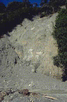 Unfortunately, the Abbotsford area,
only 8 kilometres from Dunedin, is on geologically unstable land.
The bedrock has a covering of mudstone which swells and shrinks
according to the weather. It has a very slick surface and is covered
with loose sand of up to 20 metres thick in places. The top-coating
is a very thin layer of various wind-blown soils.
Unfortunately, the Abbotsford area,
only 8 kilometres from Dunedin, is on geologically unstable land.
The bedrock has a covering of mudstone which swells and shrinks
according to the weather. It has a very slick surface and is covered
with loose sand of up to 20 metres thick in places. The top-coating
is a very thin layer of various wind-blown soils.